Defesa Civil alerta para risco meteorológico e hidrológico nesta semana - A Hora do Sul
Key Weather Alert Details
A weather alert has been issued by the Civil Defense of Rio Grande do Sul, Brazil, warning of significant risks due to a low-pressure system causing instability. This is expected to lead to moderate to heavy rain, thunderstorms, and potential hail.
Affected Regions and Rainfall
The western, Campanha, and parts of the central regions will be most affected, with accumulated rainfall ranging from 40 mm/day to 90 mm/day. Coastal areas and the south will experience less rainfall, below 40 mm/day.
Wind and Temperature
Strong winds (60-80 km/h) are expected in the northern half of the state. Minimum temperatures will range from 2°C to 11°C, and maximum temperatures from 17°C to 24°C.
Hydrological Risks and Flooding
Hydrological risks, including flooding of smaller rivers and potential major river flooding, are anticipated. Specific regions are under alert and attention levels. Flooding of the Ibirapuitã river in Alegrete is expected from Wednesday onwards.
Specific Threats
- Moderate to heavy rain with electrical discharges in the far south.
O frio marca o início da segunda-feira (16) que deverá ser marcada pela volta da chuva. A Defesa Civil do Estado emitiu alerta para risco hidrológico e meteorológico na semana, iniciando já nesta segunda por causa da atuação de uma região de baixa pressão que favorece instabilidades com chuva moderada a pontualmente forte, raios, temporais isolados com queda de granizo. As regiões mais atingidas serão Oeste, Campanha e parte do Centro, com acumulados variando entre 40 mm/dia e 90 mm/dia,
Na Costa Doce, Sul e Missões, ficam abaixo de 40 mm/dia. As rajadas de vento variam entre 60km/h e 80 km/h na metade Norte do Estado, podendo também atuar durante as instabilidades em outras regiões. As temperaturas mínimas oscilam entre 2°C e 11°C. Já as máximas, variam entre 17°C e 24°C.
Atenção para chuva moderada a forte, com descargas elétricas no Extremo Sul.
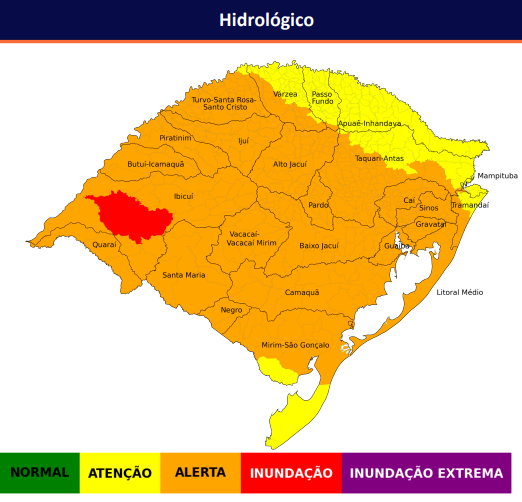
Tem risco hidrológico com ALERTA e ATENÇÃO para a região destacada no mapa, com elevação em arroios e pequenos rios, assim como cheias de rios maiores, podendo atingir limiar de atenção e alerta para inundação, além de risco de alagamentos em perímetros urbanos e enxurradas devido a chuvas intensas. A partir de quarta-feira há risco de INUNDAÇÃO do rio Ibirapuitã em Alegrete.
Was this article displayed correctly? Not happy with what you see?
If you often open multiple tabs and struggle to keep track of them, Tabs Reminder is the solution you need. Tabs Reminder lets you set reminders for tabs so you can close them and get notified about them later. Never lose track of important tabs again with Tabs Reminder!
Try our Chrome extension today!
Share this article with your
friends and colleagues.
Earn points from views and
referrals who sign up.
Learn more
Save articles to reading lists
and access them on any device